Nov.20, 2025: The occupation authorities have issued a new plan modifying the “blue line” boundaries of the Alfei Menashe settlement, in a step that constitutes a dangerous expansion of the settlement enterprise, targeting the lands of Palestinian citizens in the Qalqilya governorate and entrenching a policy of creeping annexation imposed by force on the ground.
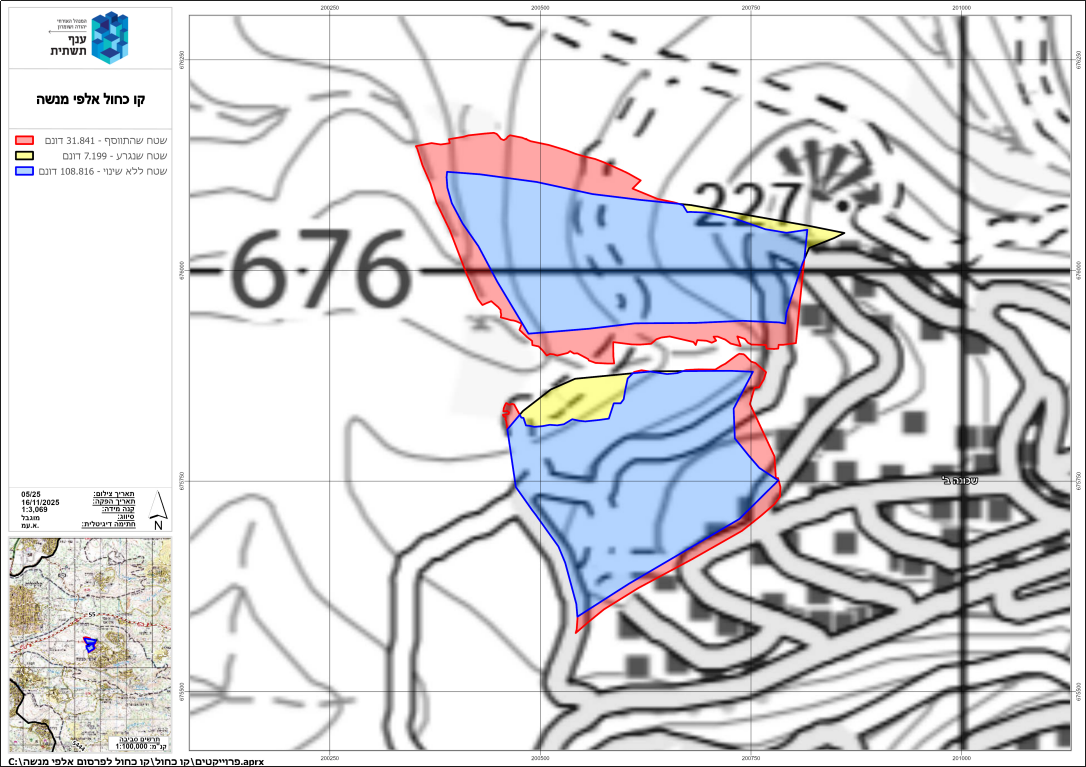
The official documents published on 11/17/2025 clearly show that the occupation added about 31.8 dunams to the area of control of the settlement, while excluding only 7.1 dunams, and keeping a total of 108 dunams unchanged.
This new modification affects wide agricultural areas in both the eastern and western sectors, and aims to link the settlement blocs together and convert the seized lands into areas designated for construction and future expansion.
Note regarding the accompanying map:
The military order map (Northwest boundary of the settlement) shows the following:
-
The blue area is the original announced area, which remained unchanged at 108 dunams.
-
The yellow area, although removed from the announcement, practically remains within the settlement boundary, totaling 7 dunams.
-
The red area represents the newly added sections to the announcement, totaling 31 dunams.
Clarifications
Since the 1990s, the occupation authorities created what became known as the Blue Line Team, a unit operating under the Civil Administration—the Israeli occupation body responsible for land and planning matters in Palestinian territories under Israeli control. It is called the “Blue Line Team” because the maps produced by this committee—maps indicating lands declared as “state land”—are outlined in blue.
The stated justification for creating this unit was that, when Israel declared vast areas of Palestinian land as “state land,” thereby prohibiting Palestinians from cultivating or using them and stripping them of ownership, it allegedly lacked modern mapping and technological tools. The occupation now claims that the Blue Line Team reviews these previous declarations to return some land to its owners—while, of course, confiscating new areas at the same time.
The work of the Blue Line Team is confined to re-delineating Palestinian lands previously seized through declarations of “state land,” usually under the pretext that they had not been cultivated for some time or that the terrain was rugged and unsuitable for farming. Portions of these lands were allocated for settlement construction, and as the settlements expanded, many extended beyond their existing master plans and even beyond their declared areas of jurisdiction—reaching into privately owned Palestinian lands outside the settlement’s official boundaries.
The danger of this re-mapping lies in the fact that no one has the right to challenge these measures in Israeli courts, even though the occupation’s announcements regarding “state land” technically allow a 45-day objection period. However, Palestinian experience—and the cumulative results of the Blue Line Team’s surveys—shows, as the maps clearly indicate, that the overall declared area of the original announcement usually remains nearly the same, with only minor changes. The real danger is that new areas of strategic value for future settlement expansion are incorporated, in exchange for removing other areas of roughly equal size.