18 December 2025 – The Head of the Wall and Settlement Resistance Commission, Minister Mu’ayyad Shaaban, stated that the occupation authorities have published a new plan to amend the boundaries of the “Blue Line” related to the Mishmar Yehuda outpost, southeast of occupied Jerusalem. This step constitutes a dangerous expansion of settlement activity targeting citizens’ land in the governorate and entrenches the policy of creeping annexation imposed by force on the ground.
Shaaban explained that reviews conducted by CWRC indicate that the occupation authorities approved the transformation of the Mishmar Yehuda outpost into a settlement in 2023, shortly after the formation of the far-right fascist government. The current decision by the Blue Line Team to define the boundaries of the new settlement reveals the occupation state’s intention to establish a large settlement comprising thousands of settlement housing units. This move adds to the race against time to alter the features of Palestinian geography and subject it to an apartheid system and colonial settlement expansion.
He added that Commission documents show that the Mishmar Yehuda outpost was included in the list of 11 outposts whose conversion into settlements was approved by the occupation government in February 2023. These include the outposts of Malachei HaShalom (where 745 dunums were declared state land for its benefit), Avigayil and Asa’el (for which land allocation orders were issued), Givat Harel and Givat Haro’eh (for which a decision was issued to merge them, and which were included in the recent declaration of 19 settlements), and Beit Hogla (for which a structural plan was recently put forward), in addition to the outposts of Sde Boaz and Shaharit. This announcement reflects the occupation state’s deepening insistence on converting these outposts into fully fledged settlements that enjoy all privileges at the expense of Palestinian land.
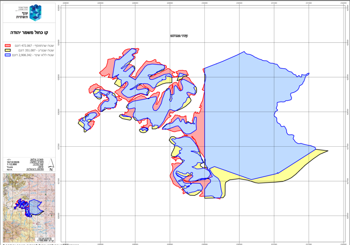
Official documents published by the occupation army on 18/12/2025 clearly show that the occupation added approximately 472 dunums to the settlement’s area of control, while excluding 351.08 dunums, and leaving a total of 2,908 dunums unchanged from the original declaration issued on 1 October 1982, under which hundreds of dunums were declared state land from the lands of the towns of Abu Dis and Al-Sawahra, south of Jerusalem.
However, this new amendment further entrenches the separation of the city of Jerusalem from the southern West Bank governorates by positioning a new settlement along the Ma’ale Adumim–Kedar settlement line to the south of the governorate.
Note on the side map:
The military order map (northwestern boundary of the settlement):
– Blue color: the declared area that remained unchanged at 2,908 dunums.
– Yellow color: areas that were ostensibly removed but in practice remained within the settlement boundaries, totaling 351.08 dunums.
– Red color: areas added to the declaration, totaling 472 dunums.
Clarifications
Since the 1990s, the occupation authorities have established what is known as the Blue Line Team, a body affiliated with the occupying Civil Administration responsible for land and construction matters in the Palestinian territories under Israeli occupation. The team is called the “Blue Line Team” because the boundaries on the maps it produces—maps that indicate land declared as state land—are marked in blue.
The justification for establishing this team was that when the occupation state declared vast areas of Palestinian land as state land—thereby prohibiting Palestinians from reclaiming or using them and effectively stripping them of ownership—it lacked technological capabilities and advanced mapping tools. Since the 1990s, it has claimed to have formed this team to review previous declarations and return land to its owners—while, in practice, also confiscating new land.
The work of the Blue Line Team is limited to re-demarcating Palestinian lands that were confiscated in the past through the mechanism of declaring them state land, under the pretext that cultivation had ceased for a period of time, or that the land was rugged and unsuitable for farming. Portions of these lands were allocated by the occupation authorities for the establishment of settlements. With the expansion of settlements, many of them extended beyond their approved planning schemes and even beyond what is known as the settlement’s jurisdictional area, reaching privately owned Palestinian land outside those boundaries.
The danger of this re-demarcation or the review of boundaries of land declared as state land—lies in the fact that no one has the right to object to it in Israeli courts. Although occupation-issued declarations nominally allow for objections within a period of up to 45 days, Palestinian experience in this context—derived from the common outcomes of Blue Line Team surveys, as reflected in the maps—indicates that the total area declared in the original order remains nearly the same, with only relatively limited variation. More dangerous, however, is that new areas are inserted into the revised demarcation map on the grounds of their strategic importance for future settlement expansion, in exchange for removing areas of roughly similar size in dunums.