

August 15, 2026: Social media accounts circulated a post attributed to the newspaper Haaretz, containing a map of Area (A)-classified areas, see accompanying map, presenting the area lying outside it in each governorate as land that has "come under control" or been "seized" by the occupation. After scrutinizing the post and comparing its figures against their original sources, it becomes clear that it involves a set of methodological, geographical, and legal fallacies; the core problem lies not in the origin of most of the percentages, but in extracting them from their context and assigning them a meaning they do not indicate.
First, the percentages contained in the post are not new data reflecting a change that occurred in 2026, nor were they first published in Haaretz. Rather, they correspond, after rounding, to the 2017 data from the Palestinian Ministry of Local Government's integrated Geographic Information System (GeoMOLG), published in a table within a study prepared by a media institution in 2022. As for the online article that could be verified on the Haaretz website, it was published on August 10, 2026, and its subject was an explanation of the Oslo division into Areas (A), (B), and (C), and not an announcement of a new annexation map or a determination of what will "remain" for Palestinians in the future.
Second, the post replaced the original description of the figures, "percentage of the governorate's area classified as (A)" with the phrase "what remains in Palestinian hands." This is a misleading characterization: Area (B) classified land, under the Oslo Accords, falls under Palestinian civil administration and includes hundreds of Palestinian villages and communities as well as vast areas of land owned by citizens. Likewise, land falling within Area (C) under the Oslo Accords does not thereby become Israeli property, nor does sovereignty over it transfer to the occupying state; rather, it means the occupation retains temporary administrative and security powers during the transitional phase that was supposed to end with withdrawal and the reaching of a final agreement.
The original table illustrates the scale of the fallacy in counting everything lying outside Area (A) as land that has "come under control":
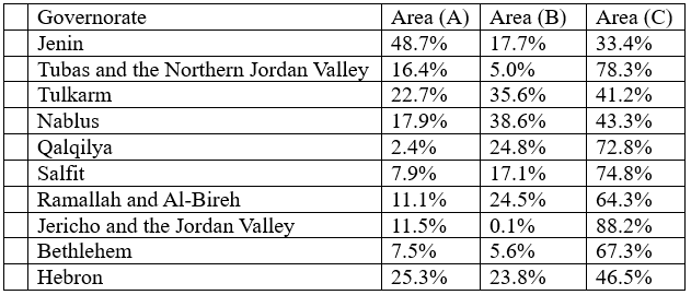
The remaining percentages in some governorates include nature reserves and areas with special classifications, such as the (H2) area in Hebron, as well as undesignated areas. For example, the post claimed that 52% of Jenin governorate had "come under control," while this percentage actually consists of 17.7% classified (B) and 33.4% classified (C). In Tulkarm, the post claimed that 78% of the governorate had been seized, when in fact 35.6% of it is classified (B), and the Area (C) portion does not exceed 41.2%. In Nablus, 82% was presented as territory under control, even though 38.6% of the governorate is classified (B), and only 43.3% is classified (C).
Third, the post used the term "seizure" incorrectly. Seizure is a legal and procedural term tied to specific military orders, each bearing a number, an area, a duration, and a declared military purpose; it may not be used as a synonym for any area lying outside Area (A). No military orders were issued in 2026 seizing the stated percentages of these governorates; rather, the area of Area (A) was simply subtracted from the total area, and the remainder was then misleadingly characterized as confiscated land.
Fourth, the post omitted Jerusalem governorate entirely, despite its inclusion in the original source table with its own special divisions and calculations, including the (J1) area located within the boundaries of the occupation's municipality in Jerusalem. This omission reveals that the post did not convey the data in full, but rather selected from it what served the predetermined conclusion it sought to reach.
In conclusion, the map does not document any new confiscation process, nor does it mean that Areas (B) and (C) have become the property of the occupying state. It is a map of temporary administrative and security divisions established under the Oslo Accords, which the occupation has since used over the past decades to entrench control and fragment Palestinian geography. The fallacy in the post lies in converting the percentage of Area (A) classified land into the concept of "land remaining for Palestinians," and in treating everything outside it as Israeli land, when in fact the West Bank, including Jerusalem, constitutes, under law, occupied Palestinian land, and the Oslo divisions grant the occupying state no right to sovereignty or ownership over it.