
July 23, 2025: The Colonization & Wall Resistance Commission revealed that the occupation authorities have approved three major plans concerning the Ma'ale Adumim colony, which is built on citizens' lands east of Jerusalem. The head of the commission, Minister Mu’ayyad Sha’ban, stated that the recently approved large-scale plans aim to create geographic continuity between the colony and the Mishor Adumim industrial zone, further isolating large geographic areas between the two colonial sites.
Mr. Sha’ban added that these plans have been deposited for subsequent approval in late 2024, just to be approved now. This exposes the occupation’s intentions to race against time to impose new facts on the ground, particularly around occupied Jerusalem. This intensifies the city’s isolation and siege through the numerous colonial measures targeting it.
Mr. Sha’ban pointed out that upon reviewing the maps and documents attached to these plans, it became clear that the three plans, which are marked in red on the attached map, complement one another to create geographic continuity between the Ma'ale Adumim colony and the Mishor Adumim industrial zone, located to the east of the colony and marked in yellow on the map.
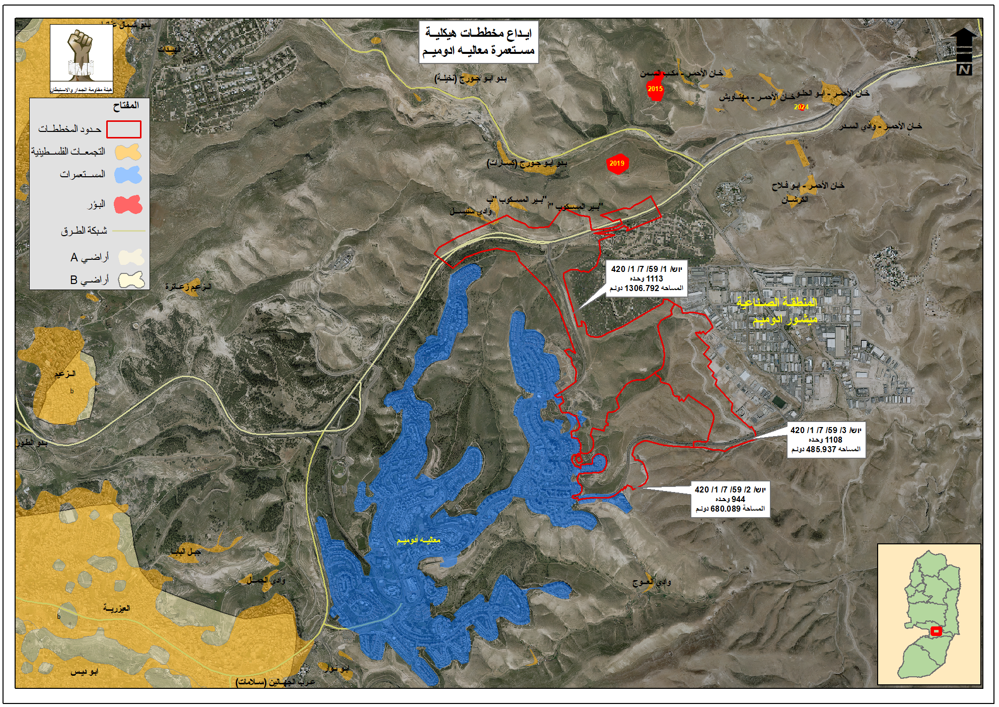
Mr. Sh’aban added that the three plans are as follows: the first master plan numbered יוש/1/59/7/1/420, in favor of the Ma'ale Adumim colony, aims to build a total of 1,113 new colonial units on an area estimated at 1,307 dunums of citizens’ land. The second plan, numbered יוש/2/59/7/1/420, aims to build 944 colonial units on an area of approximately 680 dunums, and it integrates with the first plan.
The third plan aims to build 1,108 new colonial units on an area estimated at 486 dunums. It integrates with the previous two plans with the goal of creating geographic continuity between the Ma'ale Adumim and Mishor Adumim colonies, both built on citizens’ lands between the Jerusalem and Jericho governorates. The plans mentioned here include the construction of a new colonial neighborhood, along with a new road network that further tightens control over the main road. This effectively isolates the communities of Bir al-Maskoub, Sanisel, and other nearby clusters from the communities located to the west of the colony and from the road itself, as illustrated in the map below.
Mr. Sha’ban added that throughout 2024, the occupation studied a total of 21 master plans related to colonies outside the boundaries of the Jerusalem municipality, while in the first half of 2025 alone, it submitted 28 master plans for the same geographic area, part of a large-scale, intense, and unprecedented targeting of this region.